The Global Mobile Mapping Market Is Projected to Grow at a 21% CAGR Throughout the Forecast Period
The mobile mapping industry is poised for dramatic expansion, with market valuations expected to surge to $138 billion by 2030, driven by accelerating investments in smart infrastructure, autonomous transportation systems, and advanced geospatial technologies. Industry analysts project a compound annual growth rate of 20.6% throughout the forecast period, positioning mobile mapping as one of the fastest-growing segments within the broader digital technology ecosystem.
This growth trajectory reflects fundamental shifts in how governments and private enterprises collect, process, and utilize spatial data. Mobile mapping systems combine LiDAR sensors, high-resolution imaging, GPS navigation, and artificial intelligence to capture detailed three-dimensional representations of physical environments while in motion—transforming applications from urban planning to autonomous vehicle navigation.
Smart Cities Fuel Unprecedented Demand
Global smart city technology spending reached $189 billion in 2025, marking a 22% increase over the previous year, according to IDC's Worldwide Smart Cities Spending Guide. This massive investment wave is driving mobile mapping adoption as municipalities digitize infrastructure, optimize transportation networks, and create real-time monitoring systems for utilities and public services.
In the United States, the Bipartisan Infrastructure Law and Inflation Reduction Act have allocated over $65 billion specifically toward grid modernization, broadband expansion, and resilient infrastructure, with smart technology requirements embedded throughout grant programs. These policy initiatives are accelerating demand for high-precision geospatial data that mobile mapping platforms uniquely provide.
Digital twin technology represents a particularly compelling application. These virtual replicas of urban infrastructure integrate data from mobile mapping systems, IoT sensors, and geospatial platforms to enable real-time monitoring, predictive maintenance, and scenario planning. Cities worldwide are deploying digital twins to optimize traffic flow, manage aging infrastructure, and model the impacts of development projects before committing resources.
Autonomous Vehicles Demand Centimeter-Level Precision
The autonomous vehicle revolution is creating stringent new requirements for mapping accuracy. HD maps for self-driving cars demand centimeter-level precision—typically 10 to 20 cm—to ensure safe navigation through complex urban environments. Mobile LiDAR systems meet these exacting standards while achieving remarkable productivity, surveying 50 to 100 kilometers of roadway per day and collecting millions of data points for precise documentation.
The LiDAR component of mobile mapping is experiencing even more explosive growth than the broader market. Valued at $5.3 billion in 2025, the LiDAR in mapping segment is projected to reach $45.8 billion by 2035, expanding at a 25.6% CAGR. This acceleration reflects both technological advances and expanding applications across construction, forestry, mining, telecommunications, and environmental monitoring.
Technology Costs Decline as Capabilities Expand
Economic factors are enhancing market accessibility. Industrial IoT sensor prices fell 40% between 2022 and 2025, while edge computing costs declined 55% over the same period, according to McKinsey analysis. These dramatic cost reductions make mobile mapping systems and the smart infrastructure they support increasingly viable for organizations of all sizes.
Meanwhile, technological capabilities continue advancing. Companies are integrating ultra-high-resolution cameras exceeding 74 megapixels, panoramic imaging systems capturing 13.5K resolution, and precision inertial navigation systems that maintain accuracy even in challenging environments where GPS signals are degraded or unavailable.
Market Structure and Regional Dynamics
The mobile mapping sector comprises specialized developers and global geospatial technology firms offering hardware, software, and integration services. By 2030, the market will represent approximately 3% of the projected $4,811 billion Digital Technology sector and nearly 1% of the broader $13,788 billion Information Technology market.
When analyzed by application type, 3D mapping dominates with an expected 77% market share by 2030, valued at $107 billion. This segment's strength stems from demand for detailed terrain models, extensive LiDAR deployment in engineering and construction, immersive visualization for planning purposes, and high-resolution imagery ensuring spatial precision. Corridor mapping currently represents 37.4% of LiDAR applications by market share, making it the leading use case, while ground-based surveying is the fastest-growing service segment.
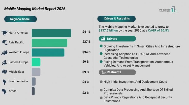
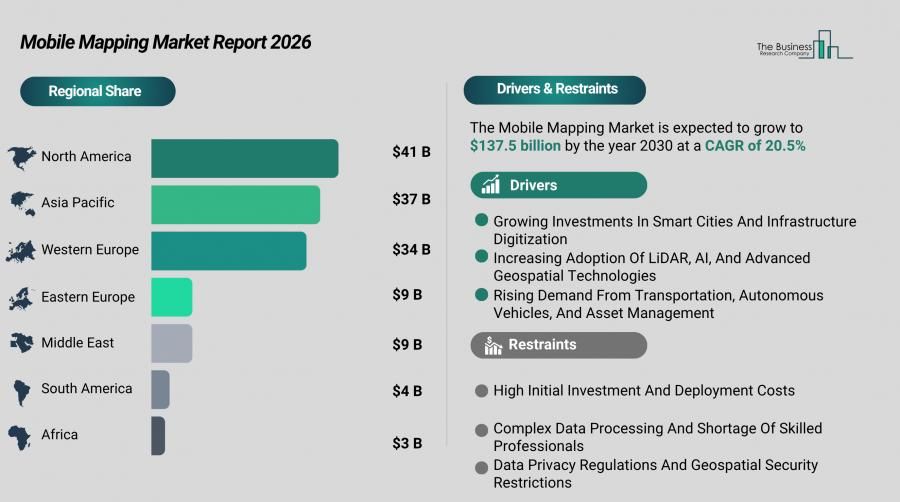
North America leads all regions, projected to account for $41 billion in market value by 2030—up from $19 billion in 2025, reflecting a 17% CAGR. The United States alone is forecast to reach $38 billion by 2030, compared to $17 billion in 2025, driven by geospatial intelligence requirements for infrastructure modernization, autonomous vehicle development, national data programs, and AI-enhanced mapping processes.
Competitive Landscape and Market Leadership
The market remains moderately fragmented, with the top ten companies collectively holding 18% of total revenue in 2025. Hexagon AB leads globally with a 3% market share, supported by total company revenue of approximately 5.42 billion EUR in 2025. The company's Geosystems division, which encompasses mobile mapping solutions, generated 1.46 billion EUR in net sales, offering comprehensive platforms combining mobile mapping systems, LiDAR sensors, imaging technology, positioning solutions, and geospatial processing software.
Other major players holding 2-3% market share include Trimble Inc., Alphabet Inc. (Google), Apple Inc., Baidu Inc., and HERE Technologies. Companies maintaining 1% shares include Topcon Positioning Systems, TomTom, Esri, and IGI GmbH. These firms compete on technological innovation, geographic reach, government partnerships, and ability to deliver integrated solutions spanning data capture, processing, and visualization.
Entry barriers are moderate but significant, requiring expertise in precision data capture, advanced sensor technology, integrated navigation systems, and scalable cloud platforms. Leading companies maintain competitive advantages through diverse product portfolios, established relationships with government agencies and enterprises, global distribution networks, and continuous innovation in LiDAR, imaging, positioning, and artificial intelligence-driven data processing.
Strategic Priorities and Future Outlook
Industry leaders are focusing on several strategic priorities:
- Developing integrated mobile mapping technologies that enhance precision and expand capabilities
- Leveraging cutting-edge LiDAR and navigation systems for improved data collection
- Broadening application scope to support infrastructure development and urban planning
- Incorporating AI technology to streamline data processing and spatial analysis
Recent product launches exemplify this innovation focus. Companies are introducing systems that combine inertial navigation with synchronized multi-camera modules, 74-megapixel resolution sensors, and panoramic imaging to provide reliable data capture and accurate mapping even in GPS-challenged environments.
The segments offering the most substantial growth potential—3D mapping and indoor mapping—are expected to add over $83 billion in combined value by 2030. Growth drivers include digital twin platform adoption, HD maps for autonomous vehicles, cloud-based geospatial data management, and real-time spatial analytics for infrastructure and facility management.
As mobile mapping technology becomes increasingly central to infrastructure digitization, autonomous mobility, and smart city development, the industry is positioned for sustained expansion well beyond the current forecast period, fundamentally reshaping how societies capture, analyze, and act upon spatial information.